The government of big landlord-big bourgeois scions Noynoy Aquino and Mar Roxas has recently announced a plan to clear Metro Manila’s waterways of some 20,000 informal settler families. Their reason is that urban poor shanties are a big (if not the biggest) factor in clogging these waterways and thus in worsening floods during the rainy season.
This has fanned the already raging fires of debate between those social sectors that hate the urban poor aka informal settlers aka squatters aka homeless poor aka scum of the earth, and those social sectors who support (or consider themselves part of) the urban poor and who believe that they are people with rights, not scum of the earth.
I will have more to say later about the points being debated by both sides. But for now, let me just focus on one simple question: What kinds of structures will be affected if we are truly serious and determined in declogging Metro Manila’s waterways? And since I don’t have the luxury of time to write a research tract on this subject, let me just focus on the very heartland of Manila—that district that surrounds the old Spanish city called Intramuros.
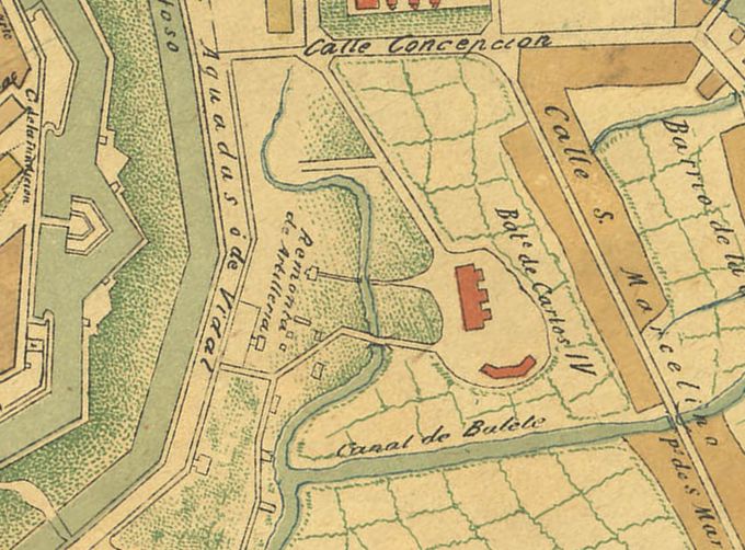
Consider Map 1A, showing the area beyond the eastern ramparts of Intramuros now traversed by Taft Avenue (including Lagusnilad) and Padre Burgos and overlooking Manila City Hall, the National Museum (the old Congress building). In 1898 and the early American period, the entire area was traversed by a complex tidewater creek called Canal de Balete and its tributaries.
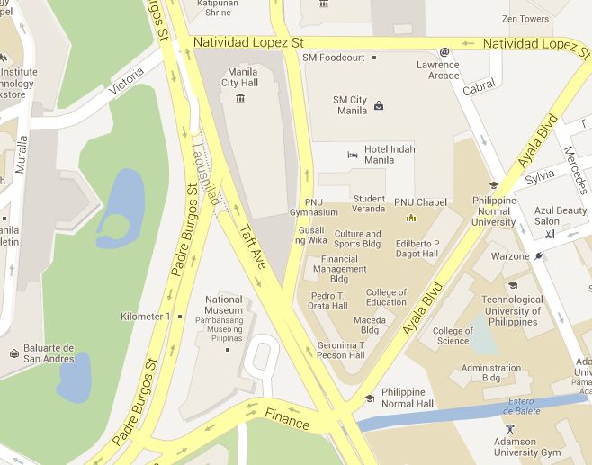
Now let’s see how the area looks now, first in Google Map (Map 1B):
And next in Google Earth (Map 1C):
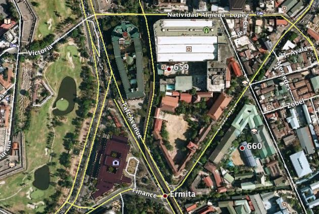
Notice that the original Canal de Balete has been drastically trimmed off. Its natural system of tributaries and runoff rivulets are now almost totally covered by concrete roads, the National Museum, the Manila City Hall, the Philippine Normal University, Hotel Indah Manila (formerly YMCA), and—surprise—SM City Manila.
The surviving Estero de Balete—a zombie of its old self despite efforts at rehabilitation—remains a stagnant and stinking dark-gray cesspool in the dry season, and a slow-flowing and greenish cesspool that doesn’t fully flush its detritus in the rainy season. Should we look far and wide for reasons why? Whenever we see Lagusnilad turn into an Olympic-size swimming pool during heavy downpours, should we look far and wide for reasons, too? I don’t think so. It’s right there staring at us.
“Clear the waterways” ba kamo? Umpisahan kaya natin sa mga istrukturang ito na bumabara sa daloy ng tubig sa pinaka-pusod ng Maynila.
Want to see another example? Let’s proceed southbound along Taft Avenue. This time, let’s inspect the current maps of this particular section of the famous Ermita district, Map 2A (a screen capture from Google Earth) and Map 2B (from Google Maps):
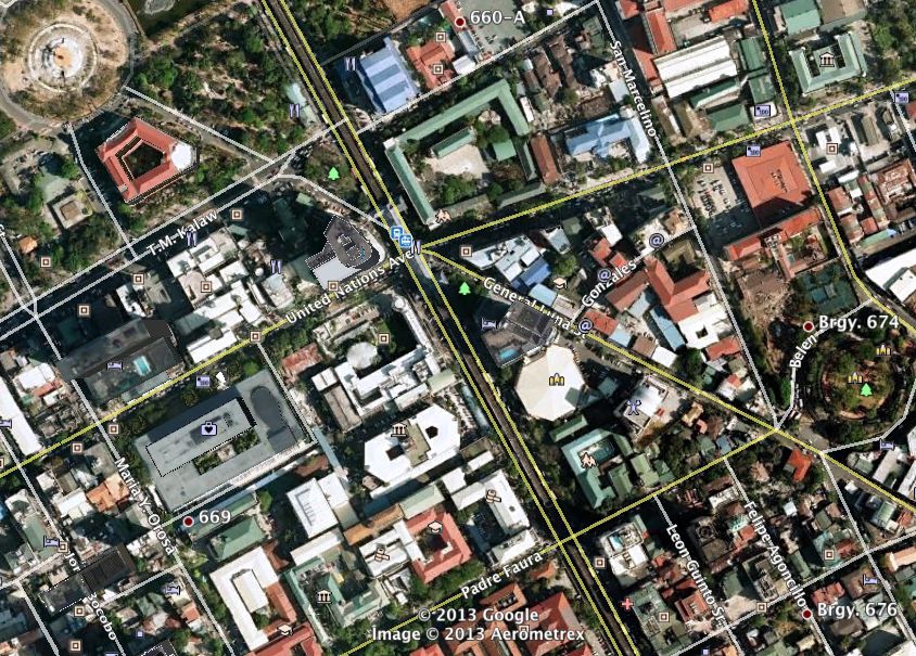
Here’s Map 2B from Google Maps:
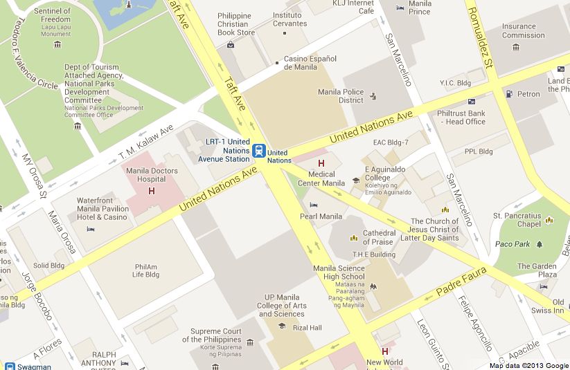
Now carefully compare these maps with their equivalent section in the old 1898 map. Notice that this other major tributary of Canal de Balete flows downstream northwest-ward, roughly parallel and to the west of what is now Taft Avenue. The swampy ox-bow loop of the waterway in the upper-left corner of the old map is now covered by the Teodoro Valencia (formerly Agrifina) Circle and the Rizal Park’s giant relief map.
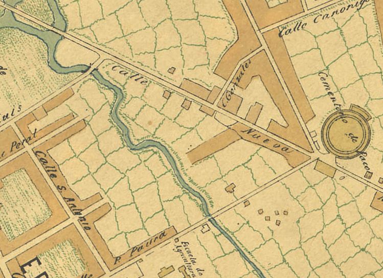
Following the waterway upstream, we see that it ran southeast between what is now Manila Doctors Hospital and the towering Times Plaza near UN Avenue’s LRT station, then right smack into the World Health Organization. After that, the now-lost waterway would have cut across the NBI and Supreme Court compounds, exited in the vicinity of the Philippine General Hospital, and farther on would have ran along some length of Taft Avenue all the way to Herran. At that point it would have extended into a small creek and rivulets in the vicinity of the Philippine Christian University and the Philippine Women’s University.
That waterway through the Taft-Ermita area is now lost, perhaps replaced by gutters, culverts and drainage mains, all underground and easily clogged by garbage from the big universities, office buildings, shops and restaurants in the area. Move along now, folks, no urban poor squatters to blame here.
So, I ask again, “clear the waterways” ba kamo? Umpisahan kaya natin sa mga istrukturang ito na bumabara sa daloy ng tubig sa pinaka-pusod ng Maynila.
I haven’t had time to double-check the paths of all other late 19th-century and early 20th-century waterways in and around Manila. But it’s almost certain that a tributary and confluence of the Estero de Bilibid (now disappeared), which more than a hundred years ago ran in front of the Presidio y Carcel Publica in Spanish times (now Manila City Jail), are now covered partly by Lerma St., partly by the Quezon Boulevard along the Recto underpass-overpass area, and partly by the Far Eastern University Campus. Upstream, this same Estero de Bilibid tributary ran roughly along what is now España Boulevard.
Sections of the complex Estero de San Miguel, now either lost or drastically constricted, have given way to commercial buildings, some industries, universities, and old residential neighborhoods (mostly middle-class, interspersed with slum housing) from eastern Quiapo and San Sebastian to Tanduay and San Miguel. A couple of big commercial properties have practically smothered estero sections that run through (or under) them, although Adamson University takes pride in its estero rehabilitation program. I haven’t even talked about the buried, dead, and dying esteros of the Binondo and Sta. Cruz-Quiapo business districts.
So, again, “clear the waterways” ba kamo? Umpisahan kaya natin sa mga istrukturang ito na bumabara sa daloy ng tubig sa pinaka-pusod ng Maynila?
Now I’ll be honest with you. I don’t really wish that these venerable buildings and thoroughfares be demolished. Many of these structures are of historical value and of continuing social service to the public. Instead of demolishing them, maybe we are better off to just carefully study and implement alternative ways of improving Metro Manila’s drainage system without majorly disrupting the city’s normal day-to-day life.
But if this callous government would insist on demolishing entire “squatter” communities and uprooting 20,000 urban poor families who have nowhere else to go (except maybe pour into the streets in mass protests if not into hills to join the NPA), then may I respectfully suggest that we start the demolition campaign by targeting some of these choice structural culprits, sitting tight and cozy, right here in the heartland of Manila.
If the law is meant to harass rather than protect people’s rights, then I insist on equal harassment under the law.#Follow @junverzola

