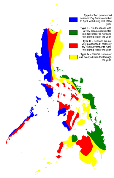
Author’s note: This was first published on 18 May 2003 under my Pathless Travels column published by Northern Dispatch (Nordis) Weekly. I’m reposting it here in three parts, with some revisions to update my own understanding of the issue, and to make it more timely. This is Part 2. Read Part 1 here.

Since the 1990s, I’ve kept some reference files and notes on Philippine climate as part of my general interest in geography and environment. I found two files particularly useful in summarizing the main types of climates in the country.
One describes the four climate types, and lists down the provinces (or parts of provinces) covered by each type. I lifted this file from a popular Philippine almanac, which in turn cites as its source a popular Bureau of Plant Industry crop calendar for various parts of the country.
The other is a Philippine climate map that I bought for 20 pesos from an ordinary bookstore. [Take note that this was in the mid-1990s, when DOST, although it was in the frontlines of building the local corridors of cyberspace, didn’t as yet have much of its PAGASA resources online.]
This particular map, about the size of short bond paper, was not very detailed and was even outright false in one respect: its longitude and latitude grids were all grossly misaligned. Once corrected, however, the map graphically displays the four climate types and proves our point about the absence of a truly countrywide rainy season from June to August or around these months. [The more accurate climate map shown above is of more recent Wikipedia provenance.]
Based on these references, we can now more confidently appreciate the four main Philippine climate zones.
Type I: pronounced rainy and dry seasons
Localities with Type I climate undergo two pronounced seasons: dry from November to April, and wet the rest of the year. Such localities are in the following:
Ilocos Norte and Ilocos Sur; Abra; La Union and Pangasinan; Benguet; western parts of Apayao, Kalinga, Mountain Province, and Ifugao; part of Nueva Vizcaya.
West-central Nueva Ecija; Tarlac, Zambales, Pampanga, and Bulacan; lowland Rizal and Metropolitan Manila; Cavite; most of Laguna (lowland) and Batangas.
Occidental Mindoro; western side of Palawan; southern half of Panay, Guimaras, and southwest Negros.
Type II: year-round rainfall, with maximum from November to April
Localities with Type II climate are almost the exact opposite of Type I. There is no distinct dry season. There is year-round rainfall, with a very pronounced rainfall from November to April. (My earlier almanac source says, “from November to January.” Oh well, blame it on climate change, or the weather analysts’ choice of algorithm.) The localities covered by Type II climate include:
Southern Sierra Madre area (Polillo islands, parts of central and southern Quezon); northern half of the Bicol peninsula (most of Camarines Norte, eastern Camarines Sur, most of Albay, Sorsogon). Based on the more recent climate map, it also includes a very thin slice of the northernmost edge of Luzon in the vicinity of Pagudpud and Sta. Praxedes.
Most of Samar; southeastern Leyte.
All of eastern Mindanao (Camiguin island, Surigao and Agusan provinces, eastern Davao del Norte, Davao Oriental); Misamis Occidental.
Type III: short and mild dry season, wet the rest of the year
Type III is a little sister to Type I. The November-April dry season is not as marked, meaning, there could be spells of rainy weather within the dry season. Localities include:
Eastern parts of Apayao, Kalinga, Mountain Province, and Ifugao; western parts of Cagayan, Isabela, and Quirino; most of Nueva Vizcaya; upland Laguna; southern Batangas; Masbate; eastern Palawan.
Northern Panay; north, central and southeast Negros; most of Cebu; Siquijor.
Most of Bukidnon and Misamis Oriental; western section of the Zamboanga peninsula; Basilan.
Type IV: no distinct dry and wet seasons, year-round rainfall
This is the classic equatorial maritime-island climate, which produces particularly lush rainforest vegetation in the bigger islands. Localities include:
Batanes; eastern coast of Luzon along most of the length of the Sierra Madre mountains (eastern side of Cagayan, Isabela, and Quirino; Aurora and northern Quezon; upland parts of Bulacan, Rizal, and Laguna); southern side of the Bicol peninsula around the Ragay gulf; Ticao and Burias islands; eastern Mindoro, Marinduque and Romblon.
Northern Cebu; Bohol; western Leyte.
Most of central and southern Mindanao (Cotabato provinces, western Davao del Norte, Davao del Sur, Lanao provinces, and eastern section of the Zamboanga peninsula); Sulu and Tawi-Tawi.
###
The two references I mentioned have been available to the public since the 1990s, probably even earlier. The digital climate map at the top of this article can be freely accessed through Wikipedia. And, of course, if you live in Cagayan Valley, Bicol or Mindanao, you will surely be aware of your locality’s different weather pattern as compared to that of, say, Metro Manila. In short, all these are of public knowledge, if only people start noticing them.
So one really wonders. Why does “Pinoy summer” and “Pinoy rainy season” persist in the public mind? I will try to offer some answers in the third and last part. #

